

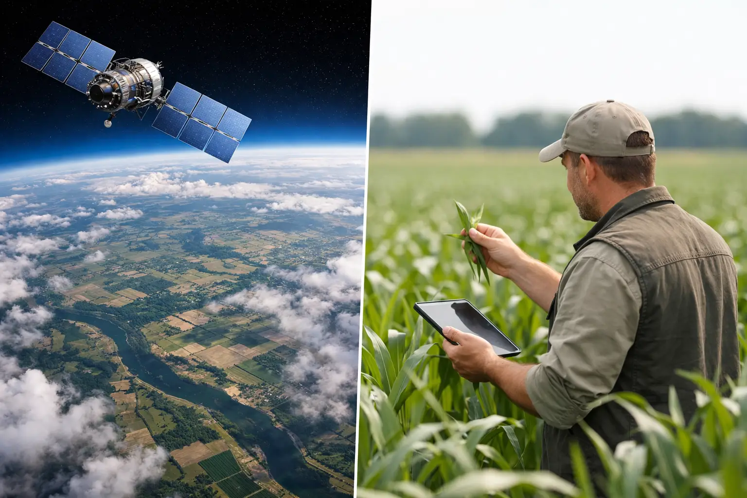
Satellite Imagery Versus Field Scouting
A 2% drop in canopy vigor across 2,000 acres can look trivial on a dashboard and still represent a major operational problem if it points to irrigation non-uniformity, nitrogen loss, or an early disease pattern. That is where satellite imagery versus field scouting becomes a practical management question, not a technology debate. For agronomists, farm managers, and agribusiness teams, the real issue is which method identifies the right problem early enough to improve the outcome.
Satellite imagery versus field scouting: the real difference
Satellite imagery is a remote measurement system. It detects variation in reflected light, surface temperature in some cases, and temporal changes across a field or across many fields. Its strength is coverage. It can show where variability exists, how patterns shift over time, and which zones deserve attention first.
Field scouting is a direct observation system. It puts a trained person in front of the crop, the soil, the root zone, the irrigation hardware, or the pest itself. Its strength is diagnosis. It can confirm whether a weak vegetation signal is caused by mite pressure, compaction, herbicide injury, emitter plugging, salinity, nutrient deficiency, or something else entirely.
This distinction matters because crop management failures often begin as subtle spatial patterns and end as biological or operational diagnoses. Satellites are very good at the first part. Scouts are essential for the second.
What satellite imagery does better
For large operations, satellite imagery changes the economics of crop monitoring. A farm manager or consultant can review hundreds of fields quickly and identify where conditions are stable, where they are deteriorating, and where intervention should be prioritized. That is difficult to replicate with manual scouting alone, especially in geographically dispersed operations.
Another advantage is historical context. Satellite platforms can compare current field conditions with previous weeks, previous crop stages, or prior seasons. That temporal view helps separate a true emerging problem from normal field-to-field variability. A weak zone that has persisted for three years may suggest soil limitations or drainage constraints. A new weak zone that appeared after a fertigation event may point to a management issue.
Satellite imagery is also useful for directing labor. Agronomy teams rarely have enough time to inspect every acre at the same intensity. Remote sensing helps allocate scouting effort to fields, management zones, and timing windows where the likely return is highest. In commercial agriculture, that prioritization is often the difference between a responsive agronomy program and a reactive one.
There is also value in standardization. Enterprise agribusinesses, processors, lenders, and public-sector programs often need a consistent way to review crop conditions across many growers or regions. Satellite-based workflows provide repeatable monitoring methods, comparable imagery layers, and a practical basis for documenting field conditions over time.
Where satellite imagery falls short
Satellite imagery does not diagnose causes on its own. It measures crop response or surface variability, not the full agronomic mechanism behind that response. A low-vigor zone may indicate water stress, but it may also reflect nematodes, root disease, poor emergence, salinity, compaction, or nutrient antagonism. Without field verification, remote sensing can narrow the search but not close the case.
Resolution is another limit. If the issue is smaller than the pixel size, mixed with adjacent plants or soil background, or emerging at a very early stage, the signal may be weak or distorted. This is especially relevant in row crops at early growth stages, orchards with variable canopy architecture, and specialty crops where within-row variation matters.
Cloud cover, revisit frequency, and image timing can also reduce operational value. A useful image that arrives three days after a critical irrigation or pest event may still support analysis, but it may not support timely intervention. For some decisions, late visibility is not enough.
Index interpretation is another common problem. Teams sometimes treat NDVI, EVI, or similar layers as direct agronomic truth. They are not. They are proxies. They can indicate where plant status differs, but they do not replace crop-stage knowledge, local field history, and ground-level evaluation.
What field scouting does better
Field scouting gives decision-makers biological certainty. A trained scout can identify lesion type, insect species, weed escapes, root development, residue distribution, stand count loss, and irrigation malfunction. Those observations directly support action. They tell the manager not just that a field is off-track, but why.
Scouting is also better for early problem characterization in situations where visual symptoms, plant tissue condition, or equipment inspection matter more than canopy-level variation. A drip irrigation blockage, for example, may first appear as a pressure or discharge issue before it becomes a clear remote-sensing pattern. A foliar disease may be detectable in the lower canopy before a satellite index reflects measurable damage.
Another advantage is context. Experienced agronomists do not just inspect leaves. They read the field system. They notice wheel-track compaction, sprayer misses, water infiltration differences, root restriction, and management execution errors that may never appear clearly in imagery. That kind of diagnosis is difficult to automate.
Field scouting also supports confident recommendations when input costs or crop risk are high. If a fungicide, topdress nitrogen pass, or irrigation correction will affect a large acreage budget, managers usually want more than a spectral alert. They want direct field evidence.
Where field scouting falls short
The most obvious limitation is scale. Even highly disciplined scouting programs cannot physically inspect every acre, every day, with the same consistency. Sampling intensity is limited by labor, travel, weather, and budget. On large operations, that means some problems are found late or not at all.
Scouting quality also varies by personnel. Two scouts may walk the same field and return with different assessments depending on training, crop familiarity, and diagnostic skill. That does not make scouting unreliable, but it does make standardization harder across regions and teams.
There is also a timing problem. Some crop issues develop rapidly between visits. Water stress, heat damage, pest flare-ups, and irrigation failures can expand materially before the next scheduled scouting pass. In that sense, manual scouting can miss the spatial and temporal continuity that satellite monitoring provides.
When each method is the better choice
If the goal is broad monitoring, zone identification, and efficient prioritization across many fields, satellite imagery is usually the better first layer. It is particularly valuable in corn, soybean, cotton, wheat, alfalfa, and permanent crops where managers need frequent visibility across large acreages. It also fits enterprise sustainability and procurement programs that need consistent field-condition monitoring across dispersed production areas.
If the goal is diagnosis, prescription, or verification before a significant management action, field scouting is usually the better method. This is true for pest and disease confirmation, irrigation system troubleshooting, nutrient deficiency interpretation, stand establishment issues, and any situation where multiple causal factors are plausible.
The choice also depends on crop stage. Early in the season, when canopy cover is limited, field scouting often has the advantage because spectral signals can be noisy. As the crop develops and canopy differences become clearer, satellite imagery becomes more useful for monitoring spatial patterns. Later in the season, scouting remains critical when the question shifts from where variation exists to what caused it and whether corrective action is still justified.
The strongest system is not either-or
The best operational model is usually satellite-guided scouting. Remote sensing identifies fields and zones that require attention. Scouting then verifies the cause, estimates severity, and supports a recommendation. This sequence reduces wasted field visits while improving diagnostic confidence.
In practice, that means a farm manager might review weekly imagery, identify an area with declining vigor near the lower end of a pivot, and send an agronomist to inspect distribution uniformity, infiltration, root health, and disease pressure. If the scout confirms waterlogging or a mechanical issue, the team can act with confidence. If the field looks clean, the analysis can shift toward fertility, salinity, or image interpretation limits.
This combined approach is especially important in professional agronomy programs where measurable improvement matters more than collecting more data. Good crop monitoring is not about generating maps or writing scouting notes for their own sake. It is about improving irrigation scheduling, nutrient use efficiency, pest response timing, and overall execution in the field.
Organizations that invest in training often see the greatest return because the technology itself is not the bottleneck. Interpretation is. A poor scout with a satellite layer is still a poor diagnostic system. A strong agronomist using remote sensing as a triage tool is far more effective. That is why many consulting and training programs, including work delivered by Cropaia, focus on integrating digital tools with field agronomy rather than treating them as separate disciplines.
A better decision framework
When evaluating satellite imagery versus field scouting, ask four practical questions. First, is the priority coverage or diagnosis? Second, how quickly must the issue be detected? Third, what is the cost of acting on a false signal or missing a real one? Fourth, does the team have the agronomic capacity to interpret variation correctly?
Those questions usually lead to a balanced answer. Satellite imagery is stronger at finding where to look. Field scouting is stronger at deciding what to do. Operations that rely on only one method often either waste time searching or make decisions with incomplete evidence.
The more disciplined path is to build a monitoring system that respects both scale and biology. Crops do not fail because data was unavailable. They fail when field variation is seen too late, interpreted poorly, or not translated into action fast enough.











About Post Author
