
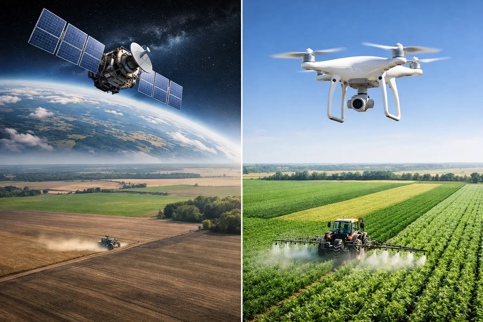
Satellite Versus Drone Imagery in Farming
A nitrogen issue can look uniform from the road and still vary sharply within 40 feet. That is where satellite versus drone imagery becomes a practical management question, not a technology debate. For agronomists, farm managers, and agribusiness teams, the right imaging method affects how quickly stress is detected, how confidently zones are defined, and whether decisions translate into measurable field improvement.
Satellite versus drone imagery: the real decision
Most comparisons start with image quality and stop there. In practice, the decision is broader. You are choosing between different operating models for crop monitoring.
Satellite imagery is built for frequency and scale. It supports routine monitoring across many fields, farms, or regions with relatively low marginal effort. Drone imagery is built for detail and control. It gives the operator the ability to capture extremely high-resolution images at the time and angle needed for a specific agronomic question.
Neither option is automatically better. The right choice depends on the crop, field size, symptom pattern, response speed required, and whether the goal is surveillance or intervention. A procurement team monitoring contract growers across a region has a different need than a farm manager trying to map irrigation non-uniformity in one almond block.
What satellite imagery does best
Satellite systems are strongest when a business needs broad coverage and repeated observation. Commercial farms, input suppliers, food companies, and public agricultural programs often need a consistent monitoring layer across hundreds or thousands of acres. Satellite platforms are well suited to that task because they can revisit the same location frequently and generate standardized data across geography.
That consistency matters. If you are tracking crop development, vegetation trends, heat stress patterns, or storm impact across a large operation, satellite imagery creates a reliable baseline. It is especially useful for prioritizing attention. Instead of sending scouts everywhere, the agronomy team can identify fields or zones showing abnormal patterns and focus field verification where it matters most.
Satellite imagery also supports historical analysis better than most drone programs. In many operations, the real value is not a single image but a seasonal pattern. Repeated observations can help distinguish a temporary stress event from a recurring problem linked to soil variation, salinity, drainage, stand establishment, or irrigation performance.
The limitation is resolution. Even when satellite data is agronomically useful, it may not show enough detail to diagnose narrow rows, early-stage variability, skips, wheel track damage, emitter failures, or localized pest hotspots. Cloud cover can also interrupt timely observation, which becomes a serious constraint when decision windows are short.
What drone imagery does best
Drone imagery is strongest when resolution changes the decision. A drone can capture plant-level or near plant-level variability that satellites often miss. That makes it useful for stand assessment, emergence checks, drainage issues, irrigation leaks, localized disease spread, lodging, spray misses, and damage evaluation after weather or field operations.
Timing control is another major advantage. If a field problem appears today, a drone flight can often be planned around that exact event rather than waiting for a satellite pass and hoping for clear skies. That flexibility matters in high-value crops and in fast-moving situations such as disease outbreaks, irrigation failures, or herbicide injury claims.
Drones also support operational precision. When imagery is detailed enough to define actionable zones, teams can use it to direct scouting, improve sampling, refine variable-rate applications, and document field conditions for internal reporting or stakeholder communication.
The trade-off is scale and workflow. Drone programs require planning, trained operators, field access, flight compliance, image processing, and data interpretation. On one farm this may be manageable. Across a large enterprise footprint, it becomes harder to sustain frequent, standardized coverage unless there is dedicated capacity.
Resolution is not the whole story
High resolution is valuable, but only if it changes management. That point is often missed.
A farm manager choosing between systems should ask a simpler question: what is the minimum level of detail required to make the next decision with confidence? If the objective is to identify which of 120 fields need agronomist attention this week, satellite imagery may be entirely adequate. If the objective is to redesign irrigation zones or verify uneven crop vigor within a few feet, drone imagery is more likely to justify the effort.
There is also a risk in very detailed imagery. More pixels can create more visual complexity without improving diagnosis. Agronomic interpretation still requires field context, crop stage awareness, weather history, fertility records, irrigation information, and ground truth. Imagery identifies patterns. It does not explain cause on its own.
Cost, labor, and scalability
The cleaner comparison is not satellite cost versus drone cost per acre. It is total cost of decision support.
Satellite imagery usually wins on scalability. For organizations managing many fields, it can deliver broad monitoring with less field labor and more consistent cadence. This makes it attractive for enterprise agronomy, sustainability programs, procurement oversight, and regional crop intelligence.
Drone imagery often wins when a specific problem carries high economic value. In permanent crops, seed production, vegetable systems, and other high-value operations, a targeted drone flight can pay for itself if it improves irrigation correction, disease response, replant decisions, or harvest planning.
Labor is a bigger separator than many budgets show. Drone operations need people who can fly safely, capture good data, process it correctly, and interpret outputs agronomically. Satellite programs shift more of the operational burden to platform providers, although internal expertise is still needed to use the information well.
Satellite versus drone imagery by use case
For routine crop monitoring across large acreage, satellite imagery is usually the more practical first layer. It helps teams see where to act without creating a heavy operational burden.
For stand counts, row-level emergence issues, drainage lines, washouts, localized weed escapes, irrigation hardware failures, and fine-scale vigor mapping, drone imagery usually has the advantage. The spatial detail is often essential.
For disease management, the answer depends on the stage and spread pattern. Satellite imagery can flag developing anomalies over large areas and support field prioritization. Drone imagery is better for characterizing patchiness, edge expansion, and within-field severity where treatment or sampling decisions require precision.
For variable-rate management, both can contribute. Satellite data may be enough to support broad zone delineation in large field crops, especially when combined with yield maps, soil layers, and field history. Drone data is more useful when zones must reflect small-scale variability or when the crop value justifies a finer prescription approach.
For reporting to external stakeholders, satellite imagery often supports consistency across regions, while drone imagery supports detailed documentation in selected fields. Many agribusinesses and public-sector programs need both perspectives.
The strongest programs use both
In well-designed digital agronomy systems, this is rarely an either-or choice. Satellite imagery often works best as the monitoring layer, while drone imagery serves as the diagnostic layer.
A practical workflow looks like this: satellite data identifies fields with abnormal trends, agronomists review weather and field records, then drone flights are deployed only where added detail is likely to improve action. That approach controls cost while preserving precision.
This layered model also improves agronomic discipline. It reduces the temptation to collect high-resolution imagery everywhere just because it is possible. The goal is not more imagery. The goal is better decisions on irrigation, fertility, crop protection, and field execution.
For organizations building agronomy capability, that is where training matters. Teams need to understand not only how images are captured, but how spectral patterns relate to crop physiology, canopy structure, water status, nutrient dynamics, and scouting strategy. Technology without interpretation creates false confidence.
How to choose for your operation
Start with decision speed, scale, and value at risk. If you oversee many fields and need regular visibility, start with satellite imagery. If you need detailed answers on selected fields and timing is critical, add drone capability.
Then assess field constraints. Small irregular blocks, frequent cloud cover, or high-value crops can shift the balance toward drones. Large acreage, geographically dispersed operations, and the need for standardized reporting usually favor satellites.
Finally, evaluate your team. The best imagery program is the one your organization can operate consistently and interpret correctly. That may mean starting with satellite-based monitoring and adding drone missions selectively as agronomic needs and internal capability mature.
Cropaia’s approach to precision agronomy reflects this same principle: use the simplest tool that reliably improves the decision, then add complexity only when it produces measurable value in the field.
The most useful image is not the sharpest one. It is the one that helps your team act at the right time, in the right place, for the right agronomic reason.