


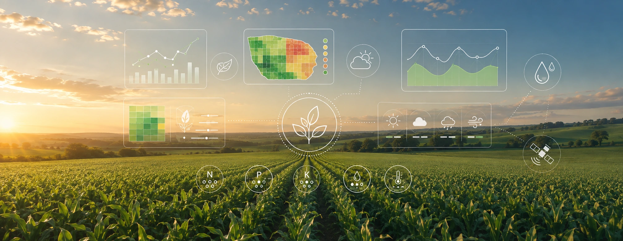
Agronomic APIs: How to Add Agronomic Intelligence
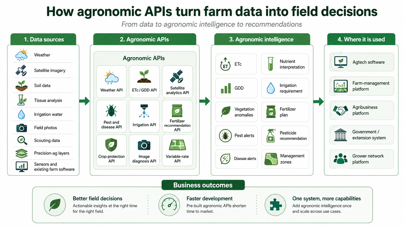
Agronomic APIs can do much more than deliver weather data or satellite imagery. They can calculate crop-specific variables, identify field anomalies, generate alerts, interpret agronomic data, and provide recommendations for irrigation, fertilization and crop protection.
This creates an important opportunity for agricultural technology companies, agribusinesses, farming organizations and government programs. Instead of developing every agronomic capability internally – or asking users to work across several different platforms – agronomic intelligence can be integrated directly into software that is already in use.
The key question when evaluating an agronomic API is therefore practical: what agronomic capability does the API actually provide?
What Is an Agronomic API?
An application programming interface, or API, allows one software system to request information or functionality from another system.
In agriculture, many APIs provide data such as weather observations, forecasts, satellite imagery or soil information. An agronomic API can take this further by applying crop-specific calculations and agronomic logic before returning the result.
Depending on the API, the output may include:
- current and historical weather data;
- crop-specific evapotranspiration;
- growing degree days and crop-development information;
- satellite vegetation indices;
- vegetation anomalies;
- pest and disease alerts;
- soil, tissue and irrigation-water interpretation;
- irrigation recommendations;
- fertilizer recommendations;
- pesticide and crop-protection recommendations;
- variable-rate application zones and prescriptions.
This distinction matters. Receiving a temperature forecast is useful, but it still requires interpretation. Receiving accumulated growing degree days for a specific crop and planting date already answers a more agronomic question. Receiving an irrigation recommendation goes further by converting multiple inputs into a field-level decision.
Agricultural Data Through APIs
Raw agricultural data remain an important part of many integrations.
A weather API may provide:
- temperature;
- rainfall;
- relative humidity;
- wind speed;
- solar radiation;
- reference evapotranspiration;
- historical weather;
- weather forecasts.
Satellite APIs may provide imagery and vegetation indices such as NDVI, NDMI, EVI and NDRE. Other services may expose soil information, sensor measurements, laboratory results or precision-agriculture data layers.
The limitation is that these values usually still need agronomic interpretation.
An NDVI value does not explain why crop development has changed. ET0 does not directly define the irrigation requirement of a particular crop. Temperature records do not automatically indicate the crop’s development stage.
For many applications, the greater value comes from processing these data according to the crop, field and production context before returning the result.
Crop-Specific Agronomic Data
Some agronomic calculations appear relatively simple until they have to work consistently across crops, planting dates, climates and production systems.
Providing these calculations through an API allows another platform to use the result without having to develop and maintain the underlying agronomic models.
Crop evapotranspiration – ETc
Reference evapotranspiration, ET0, represents atmospheric evaporative demand under reference conditions. Irrigation management generally requires another step: estimating the water use of the actual crop.
Crop evapotranspiration, ETc, accounts for crop characteristics and development. An agronomic API can therefore return ETc for a specific field rather than requiring the receiving platform to calculate it from weather data alone.
Depending on the model and available information, this may consider:
- crop;
- planting date;
- development stage;
- crop coefficients;
- weather conditions;
- canopy development.
For irrigation software, farm-management systems or agricultural IoT platforms, crop-specific ETc provides a much more useful starting point for irrigation decisions than ET0 alone.
Growing degree days – GDD
Temperature data can also be processed into growing degree days.
GDD can help estimate crop development and the timing of phenological stages and agronomic events. An agronomic API can calculate GDD according to the crop, location, planting date and relevant temperature thresholds.
This allows another agricultural application to incorporate crop-development information without building its own crop models from the beginning.
Satellite Analytics Through an Agronomic API
Satellite imagery becomes considerably more useful when the system does more than return images or vegetation-index values.
An agronomic API can calculate indices such as:
- NDVI;
- NDMI;
- EVI;
- NDRE.
These indices can be followed throughout the season to monitor crop development and spatial variability.
The API can also analyze the time series and identify unusual behavior, such as:
- a sudden decline in vegetation development;
- parts of a field behaving differently from surrounding areas;
- unexpected changes relative to previous observations;
- fields developing differently from comparable fields;
- areas that should receive higher scouting priority.
This becomes particularly valuable when an agronomist or organization is responsible for hundreds or thousands of fields. Instead of manually reviewing every satellite image, the system can highlight fields where something has changed.
An anomaly does not automatically provide a diagnosis. Reduced crop development may result from irrigation problems, nutrient limitations, root problems, pests, diseases, poor establishment or other factors. The satellite signal helps identify where investigation is needed.
Pest and Disease Alerts Through an API
Weather data can also be translated into crop-protection intelligence.
Temperature, humidity, rainfall, crop stage, location and other variables can influence the development of pests and diseases. Instead of returning these variables separately, an agronomic API can evaluate them against pest or disease models and return a risk score or alert.
The receiving system can then use the result to:
- warn growers or agronomists of increasing risk;
- prioritize scouting;
- identify fields that require inspection;
- support preventive crop-protection decisions;
- send alerts only where the specific crop and risk are relevant.
This is particularly useful for grower networks and extension programs. A single weather alert sent to every farmer has limited agronomic value. Crop-specific pest and disease alerts can focus attention on the locations and production situations where action may actually be required.
Irrigation Recommendations Through an API
An agronomic API can go beyond calculating ETc and return an actual irrigation recommendation.
This requires more field context because crop water demand is only one component of irrigation scheduling.
A field-specific recommendation may consider information such as:
- crop and variety;
- planting date;
- growth stage;
- weather and rainfall;
- ETc;
- soil characteristics;
- root-zone characteristics;
- irrigation method;
- irrigation-system configuration;
- previous irrigation events;
- soil-moisture sensor data, when available;
- water quality;
- field observations.
The result can then be returned to the existing platform as an irrigation requirement or scheduling recommendation.
For example, an irrigation-control company may already have hardware, sensors, valves and its own user interface. Adding an irrigation recommendation API allows that company to incorporate agronomic irrigation logic without replacing its existing product.
Fertilizer Recommendations Through an API
Fertilizer recommendation is another area where an API can provide agronomic functionality rather than simply data.
A fertilizer recommendation may need to consider:
- crop;
- yield target;
- soil analysis;
- plant tissue analysis;
- irrigation-water analysis;
- crop development stage;
- previous fertilizer applications;
- nutrient availability;
- fertilizer products;
- application methods;
- production or certification restrictions;
- fertilizer prices.
Cost is an important part of this calculation. Different combinations of fertilizer products may satisfy similar nutrient requirements at very different costs.
An agronomic recommendation engine can therefore evaluate nutrient requirements together with available fertilizer products and their prices. The resulting API output can include fertilizer products, application rates, timing and nutrient quantities rather than only theoretical nutrient requirements.
This capability requires more than a nutrient-removal table or simple formula. It requires agronomic logic covering soil fertility, crop nutrition, irrigation water, fertilizer composition, nutrient interactions and practical field constraints.
Soil, Plant Tissue and Water Analysis APIs
Laboratory data are another area where an agronomic API can provide interpretation rather than simply storage.
A soil-analysis API can compare laboratory results with agronomic reference values and identify relevant nutrient, pH, salinity or other soil-related issues.
A plant-tissue API can evaluate nutrient concentrations against crop-specific sufficiency ranges. Because interpretation depends on crop and often on growth stage or sampled tissue, generic thresholds are frequently insufficient.
An irrigation-water interpretation API can evaluate parameters such as salinity, sodium, bicarbonate and other water-quality factors against agronomic risk levels.
These outputs can then be incorporated directly into an existing farm-management, laboratory, advisory or agronomy platform.
Pesticide Recommendations Through an API
An agronomic API can also generate crop-protection recommendations.
The recommendation may depend on:
- crop;
- pest or disease;
- crop-development stage;
- previous applications;
- active ingredient;
- mode of action;
- pre-harvest interval;
- approved products;
- production restrictions;
- certification requirements.
The API can match a pest or disease with suitable pesticide options while checking which products remain applicable under the relevant rules.
This can be combined with pest and disease forecasting. An alert identifies increasing risk, scouting confirms the field situation, and the recommendation engine can support the subsequent treatment decision.
Diagnosing Crop Problems From Field Photos
Image analysis can also be integrated through an agronomic API.
A user can submit a field photo through an existing application and receive an assessment of possible pests, diseases or crop stress.
This type of functionality can be useful in farmer apps, scouting systems, extension tools and agronomy platforms where photo collection already forms part of the workflow.
As with satellite analytics, image diagnosis should be treated as one source of agronomic evidence. Similar symptoms may have different causes, and important information may not be visible in a photograph. The output can help narrow the diagnosis and determine what additional field information should be collected.
Variable-Rate and Precision Agriculture APIs
Agronomic APIs can also support spatial decision-making.
Precision-agriculture data may include:
- yield maps;
- soil scans;
- satellite imagery;
- field sampling layers;
- management-zone data.
An API can import and analyze these spatial layers, identify meaningful variability and generate management zones or variable-rate prescriptions.
This allows farm-management platforms, machinery systems and precision-agriculture applications to add variable-rate capabilities without independently developing the complete analysis workflow.
Why Integrate an Agronomic API Instead of Developing Everything Internally?
Building agricultural functionality internally usually involves much more than writing the software endpoint.
Crop-specific ETc, fertilizer recommendations, pest models, irrigation scheduling, pesticide rules, satellite interpretation and laboratory analysis all require agronomic knowledge. They also require development, testing, validation, data maintenance and continuous updates.
An agronomic API allows companies to integrate capabilities that have already been developed rather than recreating them internally.
This can help:
- reduce development time;
- reduce development cost;
- access agronomic expertise that may not exist within the company;
- introduce new capabilities faster;
- expand an existing product offering;
- avoid maintaining multiple crop models and agronomic databases internally.
This is especially relevant for agtech companies whose primary expertise lies somewhere else in the technology stack.
A sensor company may specialize in collecting reliable soil-moisture measurements. An irrigation company may specialize in controllers and hydraulic systems. A satellite company may specialize in imagery. A farm-management platform may specialize in planning, records and field operations.
Each can use agronomic APIs to expand the functionality available through its existing product.
Agronomic APIs for Agtech Companies
For an agtech company, APIs make it possible to add agronomic functionality while retaining its own interface, customer relationship and product architecture.
Examples include:
Farm-management platforms
A farm-management system can add fertilizer recommendations, irrigation scheduling, pest alerts, crop-protection recommendations or laboratory interpretation to the farm and field information it already manages.
Irrigation technology companies
An irrigation platform can combine its sensors, controllers or irrigation hardware with crop-specific ETc and irrigation recommendations.
Satellite and remote-sensing platforms
A satellite provider can add crop-specific analytics, anomaly detection, alerts or agronomic interpretation to imagery and vegetation indices.
IoT and sensor companies
Sensor measurements can be combined with weather, crop information and agronomic models so the application can provide decision support in addition to measurements.
Traceability and sustainability platforms
Platforms already collecting field activities, compliance records or sustainability indicators can incorporate agronomic recommendations and alerts into the same environment.
Agronomic APIs for Farms, Agribusinesses and Grower Organizations
The organization integrating an agronomic API does not have to be a software company.
Large farms, food companies, cooperatives, input companies and organizations managing grower networks often already operate digital platforms.
Introducing another standalone system can create practical problems:
- additional user accounts;
- duplicated field and grower data;
- separate databases;
- additional training requirements;
- information spread across multiple interfaces.
If the organization already has a platform that people use, an API can bring additional agronomic capabilities into that environment.
For example, an existing platform could incorporate:
- crop-specific ETc;
- GDD and crop-development information;
- satellite vegetation analytics;
- pest and disease alerts;
- irrigation recommendations;
- fertilizer recommendations;
- pesticide recommendations;
- soil and tissue interpretation.
The organization retains its existing software while expanding what that software can do.
Agronomic APIs for Governments and Extension Programs
The same approach can be relevant for governments, agricultural development programs and extension organizations.
Many already have systems containing farmer registrations, field boundaries, crop information, extension records or program-monitoring data.
Replacing these systems may be unnecessary and operationally difficult. Agronomic APIs can add specific capabilities to the infrastructure that is already in place.
For example, an institutional agricultural platform could integrate:
- crop-specific weather information;
- GDD and crop-development monitoring;
- pest and disease early warnings;
- satellite field monitoring;
- irrigation recommendations;
- fertilizer recommendations;
- decision support for extension personnel.
This is particularly relevant when the platform supports large numbers of farmers. The agronomic calculations can run at field level while the existing institutional system remains the main interface for extension personnel, program managers or growers.
What to Evaluate When Choosing an Agronomic API
A long list of API endpoints does not necessarily indicate strong agronomic capability. The important consideration is what sits behind those endpoints and whether the outputs support the intended agricultural use case.
Crop coverage
Check which crops are actually supported. Crop-specific evapotranspiration, nutrient recommendations, pest models and tissue-analysis interpretation all depend on crop-specific agronomic information.
Field-specific inputs
Determine which inputs can affect the result.
A fertilizer API that considers only crop and yield target is fundamentally different from one that can also consider soil analysis, tissue analysis, irrigation water, previous applications, available fertilizer products and their costs.
The same applies to irrigation and crop protection.
Type of output
Understand exactly what the API returns.
For irrigation, for example, the output may be:
- weather data;
- ET0;
- ETc;
- crop water requirement;
- a field-specific irrigation recommendation.
All are useful, but they serve different purposes and require different amounts of additional development by the receiving platform.
Ability to update recommendations
Field conditions change during the season. Weather changes, crops develop, new laboratory results become available, irrigation and fertilizer applications are completed, and scouting observations reveal new information.
An agronomic system should be able to use new information when recalculating recommendations rather than treating the original recommendation as static.
Integration with the existing workflow
The final output needs to fit the software and operational process where it will be used.
The API may provide a value, an alert, a recommendation, a management zone or a complete prescription. The receiving platform determines how that information reaches the agronomist, grower, extension officer or field team.
yieldsApp Agronomic APIs
yieldsApp provides agronomic capabilities that can be integrated into external agricultural software and digital platforms through APIs.
The available capabilities cover the progression from agricultural data and crop-specific calculations to analytics and field-level recommendations.
| Agronomic API | What it provides |
|---|---|
| Satellite vegetation API | Calculates vegetation indices such as NDVI, NDMI, EVI and NDRE and supports field vegetation analysis. |
| Evapotranspiration API | Calculates or predicts reference evapotranspiration and crop-specific ETc. |
| Irrigation recommendation API | Generates field- or zone-specific irrigation requirements and scheduling recommendations. |
| Weather API | Provides current and historical weather information for agricultural locations and fields. |
| Pest and disease API | Forecasts pest and disease risk and generates field-level alerts. |
| Crop-protection recommendation API | Recommends treatments and matches suitable pesticide products according to the crop, pest and applicable requirements. |
| Fertilizer recommendation API | Generates fertilizer recommendations using crop, soil, yield target and other agronomic and economic inputs. |
| Soil, tissue and water interpretation APIs | Interpret laboratory results against agronomic and crop-specific reference values. |
| Variable-rate API | Generates management zones and variable-rate application prescriptions from spatial field data. |
| Image diagnosis API | Analyzes field photographs for possible pests, diseases and crop stress. |
Additional capabilities include remote soil information, crop-development reference data, nutrient-uptake curves, pest and pesticide reference data, scouting information, precision-agriculture data analysis, agronomic alerts and field-level risk scoring.
Depending on the API, calculations and recommendations can incorporate information such as crop and variety, location, planting date, growth stage, soil analysis, plant tissue analysis, irrigation-water analysis, weather, satellite data, scouting observations, previous applications, irrigation-system characteristics, yield target, fertilizer prices and applicable production requirements.
This allows an agtech company to add agronomic functionality to its own product without developing the complete agronomic engine internally.
It also allows farms, agribusinesses, grower organizations and institutional programs to add new agronomic capabilities to platforms they already use, rather than requiring users to move between multiple software systems.
From Agricultural Data to Agronomic Decisions
Agricultural APIs can serve very different purposes. Some provide raw data. Others provide crop-specific calculations. More advanced agronomic APIs can identify risks, interpret field information and generate recommendations.
The appropriate level depends on what the receiving application needs to accomplish.
A weather application may only need observations and forecasts. An irrigation platform may need ETc or a complete irrigation recommendation. A farm-management system may want fertilizer and pesticide recommendations. A government extension platform may need field-level alerts across thousands of farms.
For companies that already have software infrastructure, integrating these capabilities through an agronomic API can reduce development effort while keeping the agronomic output inside the systems their users already know.
For agtech companies, APIs also provide a practical way to expand an existing product with additional agronomic capabilities without having to build every crop model, recommendation engine and agronomic database internally.
As agricultural software becomes more connected, the role of the agronomic API is therefore expanding from transferring agricultural data to making agronomic intelligence available wherever field decisions are already being managed.










About Post Author
